
Results: detailed display
Record 11 of 6,480 for the search Document Type Material cartográfico impreso And Institución Biblioteca Nacional de Chile


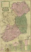
A New Map of Ireland divided into its provinces, counties and baronies, wherein are distinguished the Bishopricks, Borroughs, Barracks, Bogs, Passes, Bridges, &c. with the principal roads, and the common reputed miles / according to the newest and most exact observations by Herman Moll Geographer
Moll, Herman, (1654?- 1732) - cartógrafo
- Type Material cartográfico impreso
- Subject Irlanda - Siglo 18 - Mapas
-
Physical description
1 mapa : color, montado sobre tela ; 104 x 63 cm.
-
Description
Inserto de: descripción de la isla Purgatorio de San Patricio - Un bosquejo del condado Cawsway en Antrim - Plano de Waterford - Plano de Gallway ...Inserto de: descripción de la isla Purgatorio de San Patricio - Un bosquejo del condado Cawsway en Antrim - Plano de Waterford - Plano de Gallway - La bahía de Kingsale - plano de Limrick - Plano de Dublín - Plano de Corke - Catalogo de ciudades y lugares.
- Identifier BNC01000000000000001177514


