
Results: detailed display
Record 8 of 6,480 for the search Document Type Material cartográfico impreso And Institución Biblioteca Nacional de Chile


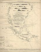
A new chart of the east & west coasts of South America from the River Plate to Valparaiso including the Falkland islands and plans of the principal harbours / drawn form the latest spanish & other surveys by J.W. Norie, hydrographer
Norie, J. W. - (John William), (1772-1843)
1922
- Place of publication Santiago, Chile]
- Edition [Santiago, Chile] : Dirección de Obras Públicas, Inspección General de Geografía Taller de la Inspección de Geografía.
- Type Material cartográfico impreso
- Subject Cartas náuticas - Estrecho de Magallanes (Argentina y Chile)
-
Physical description
1 mapa ; 67 x 53 cm.
-
Description
Publicado originalmente: London : J.W. Norie, October 1st 1822.
Número en esquina superior derecha: 24.
Incluye vistas de la entrada al puerto de Valdivia, las islas Diego Ramírez, las islas Sebaldes, el Cabo de Hornos, el Cabo Vírgenes y el estrecho de Le Maire.
Inserto incompleto de: Entrances to Rio Negro in Patagonia
Disponible en formato digital.
Reproducción electrónica. - Identifier BNC01000000000000001012712


