


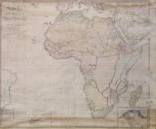
A new map of Africa including Arabia, the Mediterranean and part of the coast of South America compiled from the observations of the latest travellers, London, published the 1st. of Jany. 1800 by Rob. Wilkinson, Nº 58 Cornhill
Wilkinson, Robert (m. ca. 1825)
Baker, E.
Bourne, E.
1800
- Place of publication London
- Edition London : Rob. Wilkinson, 1 january 1800
- Type Material cartográfico impreso
-
Subject
África - Siglo XIX - Mapas
Oriente Medio - Siglo XIX - Mapas
Mapas topográficos - África - Siglo XIX
Mapas topográficos - Oriente medio - Siglo XIX
Mapas antiguos - África - Siglo XIX
Mapas antiguos - Oriente medio - Siglo XIX -
Physical description
1 mapa mural : col., montado en tela ; sobre pliego 110 x 131 cm.
-
Description
Sobre el margen inferior : "E. Baker Delin." y "E. Bourne sculp.".
Márgenes graduados. Meridianos de origen : Hierro y Greenwich. Relieve por montes de perfil y sombreado. Meridianos y paralelos dibujados formando una cuadrícula. Hidrografía. Rutas de expediciones terrestres y marítimas. Divisiones internacionales y territorios diferenciados por colores.
Contiene cuadro general de la escala según latitud y longitud, con la ubicación geográfica correspondiente a las respectivas medidas.
Debajo del cuadro, amplia nota explicativa sobre cómo encontrar la distancia entre dos lugares.
Inserciones : Sierra Leone and its environs / from the observations of W. Dawes esq., governor in 1794 - Lower Egypt / compiled from D'Anville & Pocock and improved from Bruce, Niebuhr and later travellers.
Disponible en formato digital (BNA_MA004248). - Identifier 001145407
-
UDC
912 (6)
912 (56)


