
Results: detailed display
Record 1 of 1 for the search tipo de materia Navegación - Océano Índico - Mapas
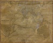
Physical chart of the Indian Ocean showing the temperature of the water, the currents of the air and ocean, directions of the wind, districts of hurricanes, regions of the monsoons & ty
foons, trade routes &c. &c. / by A. K. Johnston, F. R. S. E
Johnston, Alexander Keith (1804-1871)
W. & A.K. Johnston Limited
1848
- Place of publication Edinburgh?]
- Edition [Edinburgh?] : [s.n.], [ca. 1848] (W. & A. K. Johnston)
- Type Material cartográfico impreso
-
Subject
Temperatura del océano - Océano Índico - Mapas
Corrientes oceánicas - Océano Índico - Mapas
Vientos - Océano Índico - Mapas
Navegación - Océano Índico - Mapas
Océano Índico - Siglo XIX - Mapas
Mapas físicos - Océano Índico - Siglo XIX -
Physical description
1 mapa mural : grab., montado en tela ; 47 x 59 cm. sobre pliego 58 x 70 cm.
-
Description
Grabado por W. & A. K. Johnston.
Márgenes graduados. Temperaturas oceánicas. Direcciones y velocidades de vientos y corrientes marinas. Distritos y límites de huracanes, monzones y tifones diferenciados por colores. Rutas de navegación. Sondas batimétricas.
Temperaturas expresadas en grados Fahrenheit.
Profundidades expresadas en brazas.
Ejemplar que podría pertenecer a la obra "The Physical Atlas, a Series of Maps and Notes illustrating the Geographical Distribution of Natural Phenomena" del mismo autor.
Disponible en formato digital (BNA_MA003935). - Identifier 000635263
- UDC 912 (267)


