
Resultados: visualización detallada
Registro 1 de 1 para la búsqueda
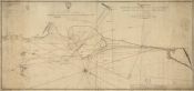
A chart of Holy Island, Fern Islands, and the Staples with the Coast from Sunderland point to Berwick; surveyed in 1791 / by Murdo Downie. Late master of his Majesty's shipthe Champion; S. Neele sculpt
Downie, Murdo
- Tipo de Documento Material cartográfico impreso
- Materia Isla Holy (Inglaterra) - Mapas
-
Descripción física
1 mapa : blanco y negro ; 50 x 109 cm sobre pliego 54 x 114 cm.
-
Descripción
"To the right honorable the Lord Comissioners of the Admiralty, this chart is by permifsion inscribed by their Lordships most obedient & most humible servant, Murdo Downie"
-
Mapa.
A scale of British Statute Miles.
Disponible en formato digital.
Reproducción electrónica. - Identificador BNC01000000000000001124503


